



CORPUS CHRISTI, Tx — CORPUS CHRISTI, Texas - Happy Friday!
WHAT YOU NEED TO KNOW
- High pressure begins to settle in overhead
- Stray to isolated shower and storm activity diminishes
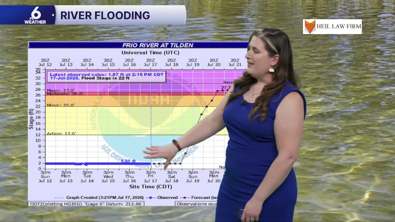
- Monitoring the Frio River flooding potential on Sunday
- High temperatures are headed towards the mid to upper 90s next week
Saturday Morning AM Clouds & PM Sun
Saturday's weather will be quite similar to what we experienced on Friday, with plenty of humidity and high temperatures in the low to mid 90s throughout the Coastal Bend. Like we've seen recently, there will be some cloud cover during the morning hours, but those clouds will give way to lots of sunshine during the afternoon, which will help to warm things up quickly. If you have any beach plans this weekend, you may notice a little bit more of a stronger sea breeze with winds blowing out of the Southeast around 20mph gusting closer to 30mph.
Tropics Update
In the Eastern Gulf, a low-pressure system is organizing off the coast of Florida. As of the 2PM National Hurricane Center update on Friday, there is a 10% chance of tropical development over the next 48 hours and a 30% chance in the next week. This is not expected to become a hurricane. If it does become something tropical, whether it is a named storm (the next name on the 2026 Atlantic Hurricane Season list in Bertha) or a depression, it will essentially be a rainmaker for the Florida Gulf Coast, and it could provide beneficial rainfall to a drought-stricken area depending on how close that low-pressure center is to land. This is not something to be concerned about in the Coastal Bend since the high-pressure area will act as a shield or block that will prevent it from reaching us. Another area of interest has been flagged by the NHC off the west coast of Africa, but odds of tropical formation are very low (10%) due to unfavorable conditions for development in the Atlantic.
Reservoir Capacity
The Texas Hill Country has been battered with torrential downpours this week, which has resulted in a surplus of rainfall and life-threatening flash flooding. Unfortunately, there have been at least two deaths associated with this impactful flooding. A large chunk of this rain water has fallen in the watershed, but it will take several days for some of the water to reach Choke Canyon and Lake Corpus Christi. It is quite challenging to forecast how much our lake levels will actually increase due to numerous factors at play (listed below), but we will most likely see the capacity increase by a few single-digit percentages. Ultimately, this will not completely resolve our water crisis, but it will have some benefits in our reservoirs.

River Flooding
We are continuing to watch out for the threat of river flooding within the watershed. The National Weather Service has a flood warning on standby for Sunday near Tilden and western Live Oak County as the Frio River is currently forecast to reach major flood status. Low-lying areas will likely be impacted the most, as floodwater may overtake roads, damage crops, and possibly reach the foundation of some homes. The Nueces River water level is starting to decline as the rainwater continues to make its way into our reservoirs. We will continue to keep you up to date with the forecast for the water levels at the Frio River.


Big Warmup Ahead
Next week, many Coastal Bend neighborhoods will experience daytime high temperatures in the middle 90s, with some areas possibly brushing up against that triple digit mark. While we're not sure if we will actually see a triple digit day in any of our neighborhoods yet, get ready for some very hot and humid summertime weather for late July! High pressure overhead will set up a heat dome pattern for the Coastal Bend, which will limit rain chances and cloud cover, and will give us a larger range between our morning lows and daytime high temps.

Stay hydrated and have a fantastic weekend Coastal Bend!
