

CORPUS CHRISTI, TX — As we’re officially over half way through the month of February, you may have noticed we’ve been pretty warm so far across the Coastal Bend! We haven’t been record-breaking in the 90s for daytime highs, yet we have seen well above average temperatures almost every single day. This persistent warmth is largely due to the jet stream remaining much further north, preventing colder, arctic air from pushing this far south.
February typically brings some more cool weather before Winter officially gives way to meteorological Spring on March 1st. In this Science Snippet, we’re going to take a look at some historical February temperatures and see how we’re stacking up so far against the all-time records.
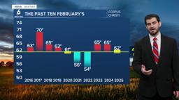
A Look Back: The Past Decade in February
Starting off with the past 10 years, we have seen a decent amount of variation in temperatures across the area if you examine any given day. Valentine's Day for example proves how we can have more than 50 degrees difference on a certain day! However, the more telling story comes when you take all of the daytime highs and morning lows and find an average temperature for the entire month. This smooths out the daily fluctuations and reveals the broader trend we experience.


For the most part, we have seen slightly above average Februaries over the past 10 years in Corpus Christi. The hottest in recent memory was back in 2017, coming in at a whopping 70°F for the monthly average! On the other end of the spectrum, the coldest was back in 2022 at 54°F. Perhaps most surprisingly, even the February of 2021 with the Great Texas Freeze came in around 56°F. This demonstrates how a few days of extreme, historic cold were offset by relatively mild temperatures for the rest of that month.
How is February 2026 stacking up against the records?
So far for the month, we’ve seen well above average daytime highs considering we should be in the lower 70s when looking at climatology. Our temperatures have frequently been in the upper 70s and even pushing the low 80s for most of the month. As of now, we’re standing with just one day below normal, one day at normal, and a good sixteen days above average. If you stack all of our days up and average them out, you come up with ~65°F. This is pretty on par with recent years coming in around the same for the monthly average in 2023 and 2024.

In terms of precipitation we’ve only seen one day of rainfall officially in Corpus Christi which was the 14th with 0.05” of rain falling at CCIA. Luckily the south side picked up more, but it still wasn’t a major event for the Coastal Bend as a whole. February is typically our “driest” month across the Coastal Bend, but we’re still behind the mark of where we should be for the month also by around ~0.75”.
A Final Taste of Winter Before Spring?
As we head into the next few days, we’ll actually see our next cold front work in, giving us one more taste of Winter. This will bring drier air and push our overnight lows down into the 40s as we kick off the final week of February. This will be a welcome, albeit brief, return to more seasonable weather.
However, the end of the month looks to warm us right back up. The big question now is whether these few cooler days will be enough to drag the monthly average down, or if February 2026 is already locked in as another notably warm month for the record books. We’ll see how the numbers officially total out in just a little over a week from now.


