

CORPUS CHRISTI, TX — November 2025 began on a stormy note with a trio of supercell thunderstorms producing large hail across some Coastal Bend neighborhoods. Some neighbors told KRIS 6 they've never seen hail like this before— and that's not surprising since this kind of weather isn't exactly common for our region of Texas. Let's dive into the climatology to compare this recent hailstorm to previous events like it!

How rare are supercell thunderstorms in the Coastal Bend?
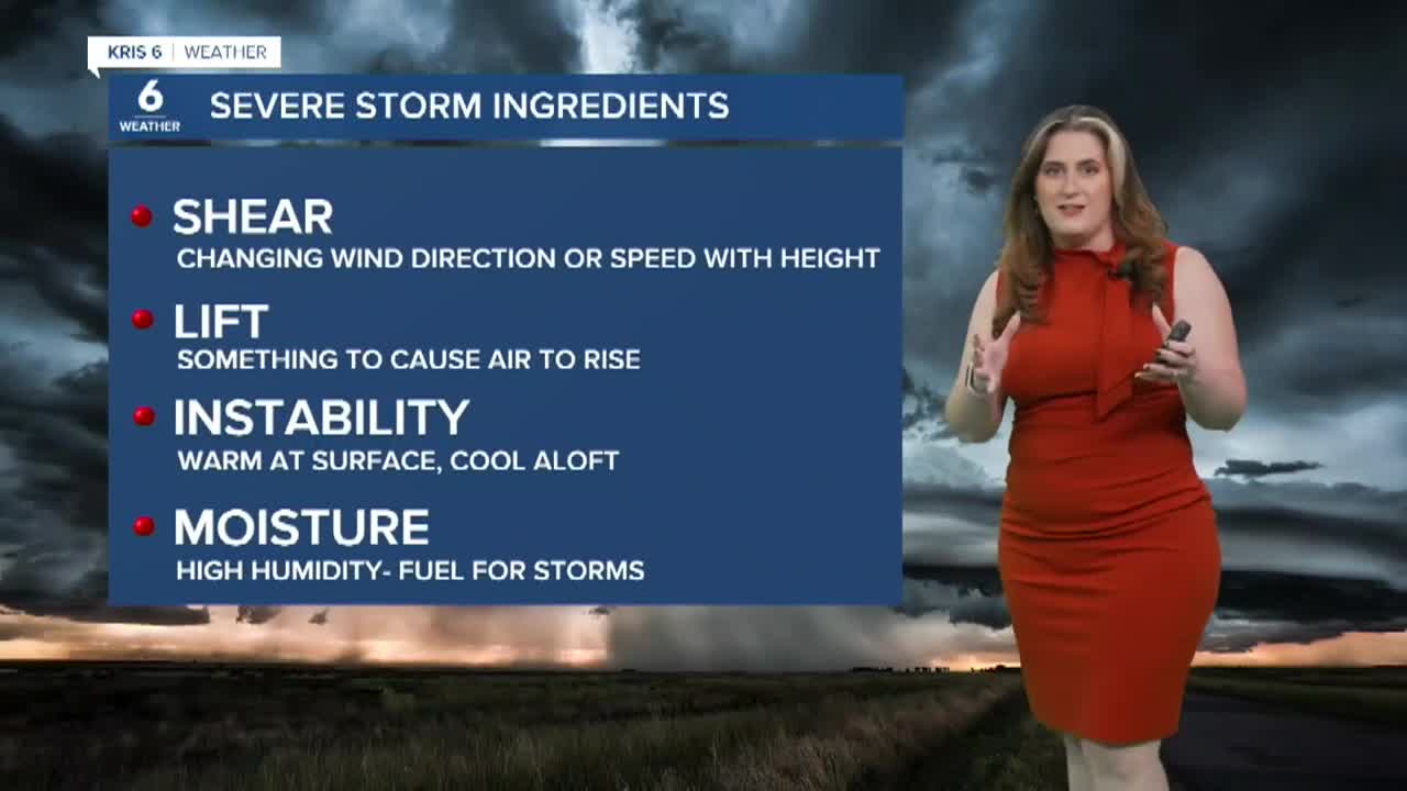
There are different types of thunderstorms; supercells are fairly rare in the Coastal Bend, but have occurred many times in the past. Supercell thunderstorms are more frequent in the Plains and the northern half of Texas. In general, severe thunderstorms require four main ingredients: shear, lift, instability, and moisture.

When severe thunderstorms happen in the Coastal Bend, they tend to occur as a (squall) line of thunderstorms. Supercells are less common because we don't usually have enough wind shear (big changes in wind direction and speed with height). When they do happen this far south, it's usually during the spring and fall. This is when upper-level troughs tend to reach farther south, deep in the heart of Texas, providing the necessary amount of wind shear. This was precisely the case on Saturday, November 1.

Particularly in the Coastal Bend, most storms "fizzle" out and weaken as they cross Highway 77 and approach the coast. This is because the marine layer of air near the Gulf weakens wind shear. So if you live in an inland neighborhood, you are more likely to see stronger storms and bigger hail.
According to climatology, the Coastal Bend experiences:
- About 75 days with thunderstorms annually
- About 10-15 Severe thunderstorms annually
- Early May = the highest likelihood of large hail (bigger than 2 inches)
- About 1-3 tornadoes annually (most are short-lived EF-0 and EF-1)
How rare is baseball-sized hail in the Coastal Bend?
As we saw this past weekend, a damaging hail event isn't unheard of, but baseball-sized hail is very rare. It's important to note that hail the size of a quarter is considered severe, so baseball-sized hailstones are very rare! But the Coastal Bend has seen even bigger!

What is the Coastal Bend's biggest hailstone on record?
When Texas Parks and Wildlife reported 3-inch hail at Mustang Island State Park on Saturday, some thought this would be the biggest hail we've seen. While this recent event will take time for NWS Corpus Christi to investigate, it could be the largest in Nueces County history. But for the entire Coastal Bend? Nope— that doesn't take the top spot!
Largest hailstones in each county (as of May 31, 2025):
- Aransas: 2.50" - Holiday Beach, 06/05/2017
- Bee: 2.75" - Pawnee, 04/30/2025
- Brooks: 1.75" - Falfurrias, multiple times
- Duval: 4.25" - Benavides, 03/31/2013
- Jim Hogg: 2.75" - Guerra, 05/08/2025
- Jim Wells: 5.00" - Alice, 05/30/1968
- Kenedy: 2.75" - Norias, 05/10/1999
- Kleberg: 4.00" - Kingsville, 03/30/1997
- Live Oak: 2.50" - SW Live Oak County, 05/10/1971
- Nueces: 2.75" - La Rosa, Petronila, W. Nueces Co.
- Refugio: 2.75" - Refugio, 12/31/1994
- San Patricio: 2.75" - Sinton, 05/10/2006
And the winner is...

These records do not include hail reports after May 2025, so the November 1 hailstorm is not included. If you'd like to look more closely at historical hail reports, click here.
