We’re still holding on to fairly windy conditions in South Texas, thanks to an upper-level disturbance moving through North Texas. Gulf moisture is quickly rushing northward to meet with the incoming weather and as the surface cold front pushes southward, it will result in widespread showers and thunderstorms developing.
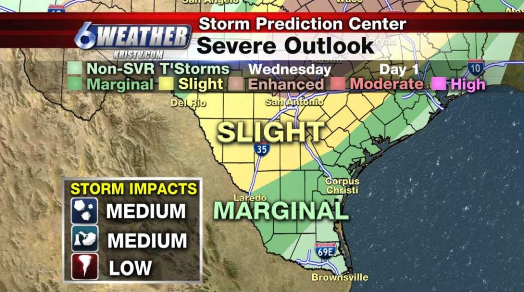
Some of those thunderstorms will become severe, but that opportunity will be higher up to the north of the Coastal Bend around the Hill Country and North and East Texas. The Storm Prediction Center (SPC) has a Slight to Enhanced Risk of severe weather for locations just mentioned.
Here in our area, we are on the tail end of the thunderstorms that will develop and the opportunity for some of those to become severe is limited, but not out of the question. SPC has most of the region in a Marginal Risk of severe storms. Strong and gusty winds of 40-50MPH, pea to quarter size hail and brief localized heavy downpours will be the greatest threats here. Also not out of the question will be the potential for tornadoes, but that threat is on the low end.
The large hail, gusty winds of 60-70MPH and a greater likelihood of tornadic activity will remain well north of South Texas where the Enhanced Risk of severe weather has been outlined by SPC.
Northwestern portions of the Coastal Bend, around Live Oak, Duval, Bee & Jim Wells counties will see the activity pick up around 1-4AM. This is when winds will increase and the time that storms will begin to push into those areas. By 3-7AM that will start pushing closer to the coastline.
Once all that pushes offshore by 8-10AM, drier air will filter in and clouds will decrease rapidly and lead to plenty of afternoon sunshine. Highs for Thursday will be in the mid 80s. Winds: NNW 15-25MPH
Friday looks like the best day with morning lows in the upper 50s with lighter winds and highs in the low 80s.
Saturday the winds will start increasing again and temperatures warm up a few degrees, but stay in the 80s. Easter Sunday we’ll look for partly cloudy skies, increasing humidity and strong winds from the south-southeast around 15-25MPH.
By the middle of next week, another front and system will approach from the northwest and will give us another shot of rain and thunderstorms. We’ll be monitoring that closely when we get closer to that time frame.
Summary:
Tonight: Cold front arrives with thunderstorms between 1-7AM, some severe…Low: 66 Winds: WSE 8-16 MPH, turning north
Thursday: Storms exit by late morning, sunshine follows, windy, warm & drier…High: 85 Winds: NNW 15-25 MPH
Friday: Chilly start, less wind, sunny & warm… High: 84 Winds: NNW 7-14 MPH
Saturday: Winds increase again, sunny and warm …High: 84 Winds: SSE 15-25 MPH
Easter Sunday: Partly cloudy, humid, windy & warm…High: 85 Winds: SSE 15-25 MPH
Monday: Clouds building up, warm and windy…High: 84 Winds: SE 15-20 MPH
Tuesday: Mainly cloudy, windy & humid, stray lt. showers…High: 83 Winds: SE 15-20 MPH


