


CORPUS CHRISTI, Texas — Upper-level high pressure and plenty of dry air that continues to swing into our neck of the wood from now Tropical Depression Ida will promote another day of scorching hot temperatures in South Texas.
We managed to achieve just shy of 100 degrees yesterday officially out at Corpus Christi International Airport and with the same weather parameters in play today, we’ll get close to it again.
Residents are urged to drink plenty of water when working outdoors for prolonged periods of time. Heat index values will shoot into the 107–114-degree range.
As previously mentioned, Ida has been downgraded into a tropical depression, but continues to bring lots of flood-provoking rains to the southeast. Tropical Storm Kate remains in the open Atlantic and will stay there. An area of disturbed weather just off the coast of Africa could quickly develop into Larry by the end of the today or tomorrow and finally we’re watching an area of disturbed weather that has a low chance of tropical formation in the southwestern Caribbean. So, the tropics are hot right now, but nothing that is threatening us in South Texas.
The dome of high pressure that is in place now will slowly spread northward, and we’ll still technically be under its influence, but it’ll have some weaknesses that will allow some tropical moisture in the form of isolated showers that will come into the area beginning Wednesday and lasting through the first part of the weekend.
Not looking at a washout any day, but the showers will be around and could yield about a quarter to half inch of rain for the lucky few who see the activity.
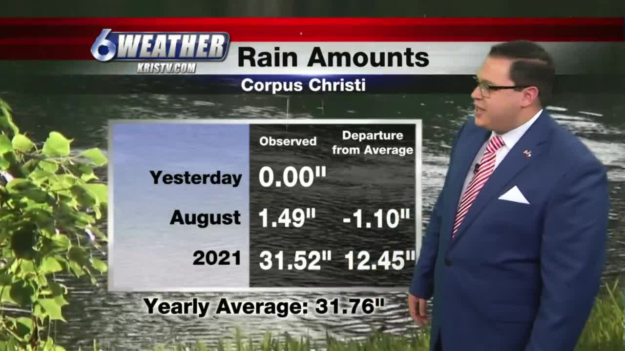
We’ll end out the month of August below normal in the rainfall department, but our yearly average is still way ahead.
Today: Sweltering hot and mainly sunny and breezy…High: 98…Heat Index: 107-114…Wind: SSE 10-20 MPH.
Tonight: Mainly clear, warm and humid…Low: 77…Wind: S 5-10 MPH.
Wednesday: Few more clouds, some isolated showers, but still, plenty of sunshine and heat…High: 96…Wind: SE 10-20 MPH.
Thursday: Partly cloudy with isolated showers, still hot…High: 96…Wind: ESE 10-15 MPH.
Friday: Best chance at a few isolated showers, staying above normal in the temp department…High: 95…Wind: ESE 10-15 MPH.
Weekend Outlook: A few isolated showers on Saturday but drying out with more sunshine and heat for Sunday. Overall, looks pretty good with a lot of heat.
Monday: Dry weather pattern takes over and sunshine and heat continue. High: Upper 90s.
Have a great day! Stay hydrated and cool!
