

CORPUS CHRISTI, Texas — Tropical Update: Tuesday Evening 7:50PM
Claudette is history while a new system is trying to form in the western Atlantic. This is indicated by the yellow X and the #1 on the satellite picture. Here are the details from the NHC.
800 PM EDT Tue Jun 22 2021 For the North Atlantic...Caribbean Sea and the Gulf of Mexico: 1. Showers and thunderstorms associated with a tropical wave located a few hundred miles east of the Windward Islands remain disorganized. This system is expected to move west-northwestward at 5 to 10 mph into an area of stronger upper-level winds by Thursday, and its potential for development appears to be decreasing. * Formation chance through 48 hours...low...10 percent. * Formation chance through 5 days...low...10 percent.

UPDATE Monday Morning at 7:35AM:
CLAUDETTE NEARING THE MID-ATLANTIC COASTAL WATERS...
...TROPICAL STORM WARNING DISCONTINUED...
The Tropical Storm Warning for eastern North Carolina has been discontinued. There are no coastal watches or warnings in effect.
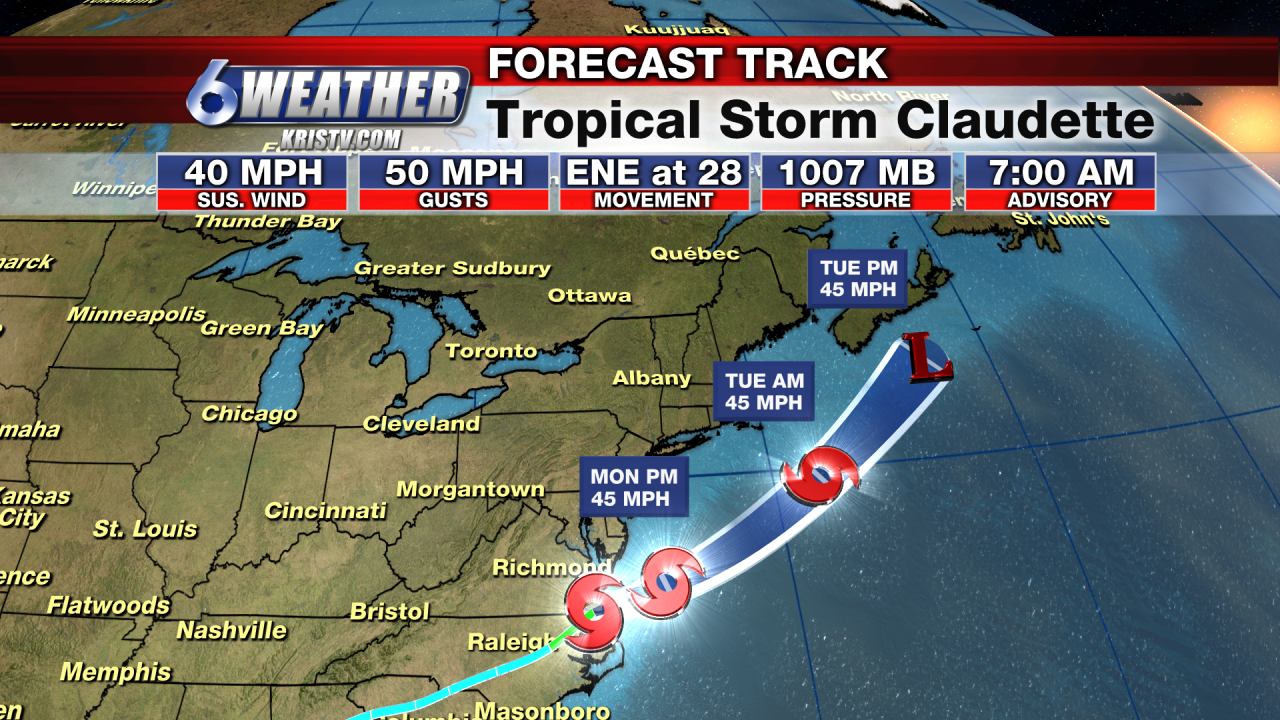
At 8 a.m. EDT, the center of Tropical Storm Claudette was located about 15 miles (25 km) west of Duck, North Carolina, and about 30 miles (50 km) south of Norfolk, Virginia. It's moving toward the east-northeast near 28 mph (45 km/h). An east-northeastward to northeastward motion with some increase in forward speed is expected over the next couple of days. On the forecast track, the system will cross into the western Atlantic Ocean later this morning and pass just south of Nova Scotia on Tuesday.
Maximum sustained winds remain near 40 mph (65 km/h) with higher gusts. These winds are occurring mostly over water, southeast of Claudette's center. Tropical-storm-force winds extend outward up to 140 miles (220 km) from the center in the southeastern quadrant. Some additional slight strengthening is possible over the western Atlantic Ocean today. Claudette is forecast to become a post-tropical cyclone Tuesday afternoon and dissipate late Tuesday night.
An additional 1 to 2 inches of rain is expected across far eastern North Carolina during the next few hours. Isolated flash, urban, and small stream flooding impacts are possible.
For the latest rainfall reports and wind gusts associated with Claudette, see the storm summary at https://www.wpc.ncep.noaa.gov/discussions/nfdscc3.html
--------------------------------------------------------------------------------------------------------------------------------------------------
UPDATE Friday Morning at 7:45 AM:
Potential Tropical Cyclone #3 continues to be very disorganized this morning, but is beginning to show signs of slow strengthening with evident deep convection trying to form around the center of circulation.
The National Hurricane Center has the system forecast to become a minimal Tropical Storm, would be named Claudette, later today and make landfall just south of Morgan City, Louisiana early Saturday morning.
Here in Corpus Christi, we remain on the dry side, but we'll see coastal effects in the form of larger swells, increased rip currents and some minor coastal flooding possible. Mariners are urged to use caution and those headed to the beach are encouraged to keep an eye on the Beach Flag's as it is likely that red flags will be flying for dangerous rip currents. Inexperienced swimmer, even experienced ones, should stay near lifeguards.
Here are the Key Messages from the National Hurricane Center as of 7AM Friday:
KEY MESSAGES: 1. THE SYSTEM IS EXPECTED TO PRODUCE HEAVY RAINFALL, CONSIDERABLE FLASH, URBAN AND SMALL STREAM FLOODING BEGINNING TODAY AND CONTINUING THROUGH THE WEEKEND ALONG THE CENTRAL GULF COAST WITH FLOOD IMPACTS SPREADING NORTHEASTWARD INTO THE SOUTHERN APPALACHIANS. 2. TROPICAL STORM CONDITIONS ARE EXPECTED TO BEGIN TODAY IN AREAS NEAR AND WELL TO THE EAST OF THE CENTER ALONG PORTIONS OF THE CENTRAL GULF COAST FROM INTRACOASTAL CITY, LOUISIANA, TO THE OKALOOSA/WALTON COUNTY LINE, FLORIDA, INCLUDING NEW ORLEANS.
Stay with KRISTV and the 6WEATHER Team for all the latest!
-------------------------------------------------------------------------------------------------------------------------------------------------------
Initial Post (Thursday 6/17/21) Evening: The National Hurricane Center has issued the first tropical advisories of the 2021 Hurricane Season.
Parts of the Gulf Coast are under a Tropical Storm Warning as Potential Tropical Cyclone #3 (PTC #3) moves northward in the Gulf of Mexico. These warnings mean that tropical storm force winds are expected in the warned areas within 36 hours. Tropical Storm Warnings are posted from Intracoastal City, Louisiana to the Alabama/Florida border.
While the storm is not yet a Tropical Depression, is is expected to become one late Thursday, early Friday morning; and a named Tropical Storm by Friday afternoon. The next name on the list is Claudette.
PTC #3 will not directly impact the Coastal Bend, but the passing storm will churn up the waters along our Gulf-facing beaches on Friday into Saturday. PTC #3 is currently forecasted to be the first landfalling Tropical Storm of the 2021 Hurricane Season.