

CORPUS CHRISTI, TX — Meteorologists classify damaging windstorms in a variety of ways, but two of those categories are straight-line and tornadic. The difference lies in the type of damage and the originating severe storm structure. Straight-line winds originate from what is called a downburst, a down-rushing of wind from a severe thunderstorm. The downdraft strikes the ground and spreads out as a horizontal wind field, diverging as it impacts the ground. Wind speeds can exceed 150 mph in the most severe of downbursts, resulting in catastrophic localized damage. Larger downbursts (greater than 2.5 miles across) are classified as macrobursts. Those less than 2.5 miles across are called microbursts. A tornado, on the other hand, is a violently rotating column of air attached to a thunderstorm and in contact with the ground.
The visual appearances of downbursts and tornadoes are starkly different on radar, especially in the velocity signature. In the case of the Coastal Bend macroburst (above) the bright green feature (west of KCRP) is moving quickly east and has measured winds in excess of 110 mph. The second image is that of a tornadic circulation south of Lampasas, TX with rotation implied by bright green moving away from the radar next to bright red moving toward the radar.
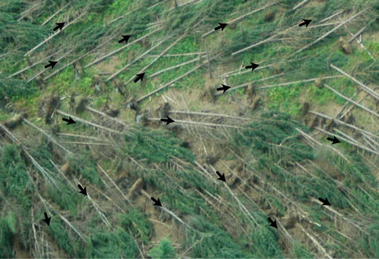
From an aerial survey, downburst damage is seen to diverge, or spread out, as indicated with this image:
Tornado-induced damage creates a different pattern, one clearly indicating rotating, or at least converging, winds:

For the homeowner or landowner, damage is damage. Ultimately, tornadoes are the most violent form of windstorm, with speeds exceeding 300 mph. Nevertheless, when a severe thunderstorm warning is issued for your area and the warning specifically mentions damaging winds, take it very seriously.
Catch all the KRIS 6 News stories and more on our YouTube page. Subscribe today!