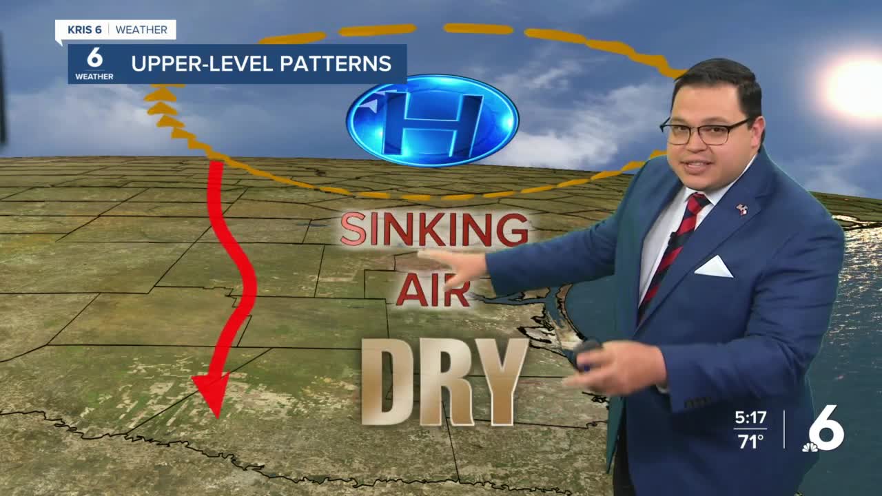


CORPUS CHRISTI, Texas — Upper-level high pressure will begin building across the South Texas region today, while the more active weather patterns stay far to our north.
This means a couple of things for us here at home.
The first, with high pressure in place, we’ll begin to see more days returning to our normal very warm and sunny/partly cloudy skies. Rain chances when high pressure is in control stays very limited to none.
The other thing will be gusty winds coming off the Gulf and resulting in higher humidity levels each day. As low-pressure systems move from west to east in the Central Plains, that tightens up our pressure gradients here in the Coastal Bend and results in all the winds that will certainly be a part of our forecast for the next several days right on into next week.
If you have travel plans up to the northern parts of the state over the weekend, those areas will have a better shot at some showers and storms as the surface frontal boundaries associated with the upper-level lows will stall out in those areas and bring chances of rain for them. We’ll be left on the mainly dry side of things and only see the opportunity for one or two showers to migrate towards our area before burning off with the high winds.
With that said, it’s looking more and more likely that we’re entering a dry trend through the next 7-10 days.
For the rest of the week, into the weekend and early next week, we’ll be dealing with above normal temperatures, windy conditions, and high humidity. With the increased winds, the rip current threat will increase along the Gulf-facing beaches, and it will be possible for water to reach up to the dunes during times of high tide. Those looking to beat the heat are urged to use caution and small craft caution and advisories are likely to be posted through early next week.
Today: Partly cloudy, very warm and humid with increasing winds…High: 86…Wind: SE 15-25 MPH & gusting.
Tonight: Staying breezy, a few clouds and muggy conditions…Low: 71…Wind: SSE 10-20 MPH.
Friday: Good mix of clouds and sunshine with winds becoming stronger; staying very warm and muggy…High: 88…Wind: SSE 15-30 MPH & gusting near 40.
Saturday: A few extra clouds, showers out to our north, many of us stay dry here with warm temperatures, gusty winds & high humidity…High: 89…Wind: SSE 15-30 MPH & gusting.
Sunday: Partly to mainly cloudy skies, gusty winds, very warm and humid; coastal flooding possible along beaches along with high rip currents…High: 88…Wind: SSE 15-30 MPH & gusting.
Monday: Holding on to partly to mainly cloudy skies with rain chances to our west and north, we stay mainly dry, windy and very warm…High: 88…Wind: SSE 15-30 MPH.
Tuesday: Mainly cloudy, still very warm and muggy with gusty winds…High: 89…Wind: SSE 15-30 MPH & gusting.
Have a great day!
