


CORPUS CHRISTI, Texas — Daily rainfall chances to South Texas is allowing us to chip away at our rainfall deficit which was over 10 inches below normal at the beginning of August.
Believe it or not, as of this morning, we have had over 9.50" of rain officially out at Corpus Christi International Airport for the month of August and our deficit has been dwindled down to 2.33" and with more rain in the forecast it is going to head lower.
We continue to have an open tap of tropical moisture that is streaming off the Gulf and with the help of a few surface and mid-level disturbances in the atmosphere, we're firing off daily isolated to scattered showers and storms in the area.
Keep in mind that any thunderstorm activity that forms will be capable of heavy rainfall rates of 1-2"/hr which could lead to some localized flash flooding. With our grands saturated, any heavy downpour may lead to water of the roads and causing ponding to occur as well. If you are driving and find yourself in thunderstorm activity, be sure to slow down and always be aware of your surroundings.
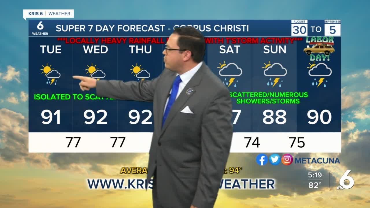
The forecast calls for the rainfall to be isolated to scattered through the end of the week, but that will increase to widespread to numerous as we head into the Labor Day Holiday Weekend as more tropical moisture moves in from the Gulf. So, unfortunately, if you are planning outdoor activity, it may be a good idea to have a plan to be indoors.
Rainfall amounts of 2-4 inches could be possible by the time we head into early next week.
There continues to be two areas of disturbed weather in the Central Atlantic this morning. They have a moderate to high chance of development in the next 5-days. Danielle would be the next named storm. Neither are threatening the Gulf or South Texas. We'll be keeping an eye on it. Always a good idea to be sure you have a hurricane plan as we head into the peak of hurricane season.
Today: Partly to mainly cloudy with another round of isolated to scattered showers and thunderstorms with some locally heavy rainfall possible causing some spotty flash flooding…High: 91…Wind: ESE 10-15 MPH…Heat Index: 106-112.
Tonight: Mainly cloudy skies, a few showers; quiet and muggy…Low: 77…Wind: ESE 3-6 MPH.
Wednesday: Good amount of cloud coverage and isolated to scattered showers and storms with locally heavy rain possible…High: 92…Wind: E 10-15 MPH…Heat Index: 105-110.
Thursday: Mainly cloudy skies with isolated to scattered showers and storms…High: 92…Wind: E 10-15 MPH…Heat Index: 105-110.
Friday: Mainly cloudy with some heavy rain possible associated with isolated to scattered showers and storms…High: 92…Wind: ENE 10-15 MPH…Heat Index: 105-110.
Saturday: Cloudy with tropical moisture increasing over South Texas resulting in more scattered to numerous showers and storms with localized flash flooding possible…High: 87…Wind: ENE 10-15 MPH.
Sunday: Overcast and muggy with scattered to numerous showers and storms in the area; some will be locally heavy with some flash flooding possible…High: 88…Wind: E 7-14 MPH.
Have a great day and be safe on the wet roads. Always be aware of your surroundings and get to your destinations safely.
