UPDATE: Around 4:30-5:30PM a little disturbance moved through near the coastline and provided mainly virga (rain that precipitates from the clouds, but never reaches the surface because of dry air); however some of the ice crystals that were in the clouds made it through the dry air all the way down to the surface and gave some Corpus Christi residents some hail. Extremely rare event!
We’ve had a fantastic Sunday in the Coastal Bend with a good amount of sunshine sending temperatures near seasonal average in the upper 60s to low 70s. All this courtesy of a front that came in yesterday and slowly pushed the cloud coverage off in the Gulf of Mexico.
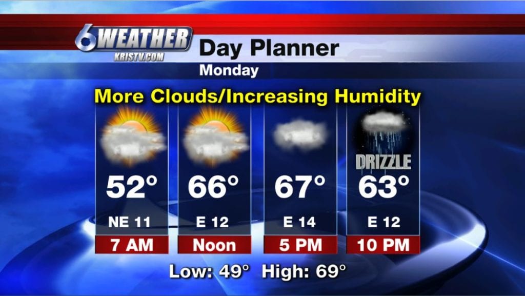
In the short term forecast, we have high pressure in control and will promote mainly clear skies. This won’t last long though as the high pushes east fairly rapidly and throughout the day tomorrow that will give us a more southeasterly wind in the area and increase humidity, clouds and some light rain/drizzle.
Tonight, clouds will be on the increase. Temperatures will still be on the chilly side with upper 40s to low 50s over much of South Texas. Winds: ENE 5-10 MPH
Monday will feature a noticeable increase in clouds with temperatures in the upper 60s to low 70s, very similar to this afternoon. Winds: E 10-15 MPH
By late Monday and into Tuesday, the light showers and drizzle will increase as a warm front moves our direction from the south and acts as a culprit to set off the light rain. This will ensure clouds stick around, the humidity stays and will also warm up temperatures back into the 70s by Tuesday afternoon despite the cloud coverage. Rain amounts are not forecast to be impressive, with many locations receiving only a few tenths.
The increase in humidity will also result in more sea fog late in the evenings and early morning hours beginning Tuesday through early Friday morning.
We’ll keep a good amount of clouds through the rest of the week and highs will shoot back into the low 80s by Thursday and Friday. Friday we’ll see a bit more sun as the next cold front sweeps down into North Texas.
That front will arrive here in South Texas early Saturday morning with a few showers with its passage then cooler and drier air will filter in along with very windy conditions. We won’t clear out completely, but there will be some sunshine for the afternoon before clouds come back along with light showers on Sunday.
Have a great week!
Summary:
Tonight: Increasing clouds, still on the cool/chilly side…Low: 49 Winds: ENE 5-10 MPH
Monday: Mainly cloudy with increasing humidity…High: 69 Winds: E 10-15 MPH
Tuesday: Warm front moves through; cloudy, humid and drizzle…High: 73 Winds: SSEE 7-14 MPH
Wednesday: AM fog, cloudy, stuffy and mild… High: 76 Winds: SSE 7-14 MPH
Thursday: AM fog, warmer and still humid with plenty of clouds…High: 80 Winds: SSE 10-15 MPH
Friday: Partly cloudy, warm, humid and breezy…High: 82 Winds: SSE 10-20 MPH
Saturday: AM cold front with showers, very windy, cooler, PM partly cloudy…High: 66 Winds: NNE 20-35+ MPH & gusting