Tropical Storm Gordon formed south of Florida early Monday morning, bringing some heavy rain and gusty winds to southern parts of the Sunshine State.
The National Hurricane Center has Gordon moving west-northwest at approximately 16MPH and will eventually emerge in the eastern Gulf of Mexico later this evening. Tropical Storm Warnings are posted for parts of Florida and stretch all the way over towards Louisiana where even some Hurricane Watches are posted. Gordon could potentially bring 4-6 inches of rain with some isolated pockets of 7-9 inches for those in the path. The official forecast from the NHC has Gordon making landfall in Louisiana around New Orleans late Tuesday evening.
Here in the Coastal Bend we continue to have plenty of moisture in place from a tropical wave near Houston and also a few disturbances moving east from Mexico. The combination of all this and the afternoon seabreeze kicking up with daytime heating, there have been a few isolated to scattered thundershowers in the region. This will continue over the next several days. Not everyone will participate in the rain each day, but for those who do; heavy downpours will be possible dropping a quarter to half inch of rain in a short amount of time.
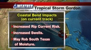
Gordon will not have any direct impacts here in the Coastal Bend, but we will see some indirect impacts in the form of increased swells and increased rip current risks for Gulf facing beaches. Boaters and mariners are urged to exercise extreme caution over the next several days, especially out in the open waters.
Tonight will still be warm and muggy with lows in the middle 70s with southeasterly winds around 5-10MPH.
Tuesday will feature another round of scattered thundershowers and highs in the low to mid-90s. Wind: ESE 10-20MPH
Wednesday will feature another round of scattered thundershowers and we’ll start to see less activity, not completely gone though, for the remainder of the week and into next weekend with highs in the low 90s. Depending on the intensity of Gordon during landfall, and after moving inland, it could throw some drier air towards South Texas and drop rain chances even further. We’ll continue to monitor this complex forecast very closely the next few days and update as necessary.
Summary:
Tonight: Muggy and warm…Low: 76 Winds: SE 5-10 MPH
Tuesday: Mostly cloudy/scattered thundershowers…High: 94 Winds: ESE 10-20 MPH
Wednesday: Mostly cloudy/scattered-num. thundershowers…High: 90 Winds: ESE 6-12 MPH
Thursday: Mostly cloudy/isolated thundershowers (watching tropics)…High: 93 Winds: ESE 7-14 MPH
Friday: Mainly cloudy/isolated thundershowers …High: 93 Winds: SE 8-16 MPH
Saturday: Mainly cloudy/isolated thundershowers … High: 93 Winds: SE 10-15 MPH
Sunday: More sun breaking through/stray-isolated thundershowers…High: 94 Winds: SE 10-15 MPH